The envelope of air around the earth is known as Atmosphere. It is a mixture of different gases. It contains life-sustaining gases like oxygen for humans and carbon dioxide for plants.
Composition of Atmosphere
The atmosphere is composed of gases, water vapour and dust particles.
Gases:
Nitrogen: 78%
Oxygen: 21%
Argon: 0.93%
Carbon dioxide: 0.04%
Neon: 0.0018%
Helium: 0.0005%
Ozone: 0.0006%
Hydrogen: 0.00005%
Carbon dioxide allows the incoming solar radiation but it is opaque to the outgoing solar radiation. Hence it keeps the temperature of earth warm. It is known as greenhouse effect.
Ozone gas protects the earth from harmful UV radiations coming from the sun.
Water Vapour
- It is a variable gas in the atmosphere which decreases with altitude.
- It also decreases from equator towards the poles
- It absorbs parts of the insolation from the sun and preserves the earth’s radiated heat. Hence it also acts as a blanket.
Dust Particles
- This includes sea salt, fine soil, smoke soot, ash, pollen and disintegrated particles of meteors.
- These particles are concentrated in the lower layers of the atmosphere.
- The higher concentration of dust particles is found in sub-tropical and temperate regions due to dry winds in comparison to equatorial and polar regions
Structure of the Atmosphere
The atmosphere consists of different layers with varying density and temperature. Density is highest near the earth’s surface and it decreases with increase in altitude.
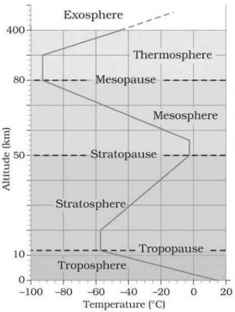
Troposphere
- It is the lowermost layer of the atmosphere consisting of dust particles and water vapour.
- All climatic and weather changes take place in this layer.
- Temperature in this layer decreases at the rate of 10C for every 165m of height.
- The height at which the temperature stops decreasing is called tropopause.
Stratosphere
- It is found above tropopause and it extends up to a height of 50km.
- This layer contains ozone layer.
- This layer is free from clouds and associated weather phenomena. Hence, it provides ideal conditions for jet planes
- At the end of this layer, temperature begins to fall again, which is called stratopause.
Mesosphere
-It lies above the stratosphere and it extends up to 80km
-In this layer also, temperature begins to drop again and reaches up to -1000C at the
height of 80km
-This layer ends at mesopause
Thermosphere/Ionosphere
- It is located above mesopause between a height of 80km and 400km.
- It contains electrically charged particles (ions) and it is known as ionosphere.
- Radio waves transmitted from the earth are reflected to the earth by this layer.
- In this layer, temperature starts increasing with height.
- This layer protects us from meteors and obsolete satellites because its high temperature burns up all the debris coming towards the earth.
Exosphere
- It lies above thermosphere and it is the uppermost layer of atmosphere.
- This layer contains only traces of gases like oxygen, nitrogen, argon and helium because of the lack of gravity.
Atmospheric Pressure
The weight of air column contained in a unit area from the mean sea level to the top of
atmosphere is called atmospheric pressure. It is expressed in milibar or ATM or Bar.
- At sea level, the average atmospheric pressure is 1013 milibar.
- Atmospheric pressure is measured by mercury barometer or aneroid barometer.
- In the lower atmosphere, the pressure decreases with height.
Wind
Moving air is called wind. The wind blows from high pressure to low pressure. There are 3 important factors which affect the direction and speed of wind –
- Pressure gradient – The rate of change of pressure with respect to distance is called pressure gradient. It is strong where isobars are close to each other and is weak where isobars are apart. Higher the pressure gradient, more is the velocity of wind and larger is the deflection in the direction of wind.
- Frictional force – It affects the speed of the wind.Over the sea surface, this friction is minimal.
- Coriolis force – The force exerted by rotation of earth (Coriolis force) affects the direction of wind. It defects the wind to right direction in northern hemisphere and to the left in southern hemisphere.
Coriolis force is perpendicular to angle of latitude, It is maximum at poles and zero at equator. At the equator, the Coriolis force is zero and the wind blows perpendicular to isobars. Coriolis force is perpendicular to pressure gradient which is perpendicular to isobar
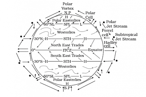
General circulation of Atmosphere
The pattern of movement of planetary winds is called the general circulation of atmosphere. The pattern of planetary wind depends on –
- Latitudinal variation of atmosphere
- Emergence of pressure belts
- Distribution of continents and oceans
- Rotation of earth
Effect of General Atmospheric Circulation on Oceans
- The strong winds of the atmosphere initiate the movement of ocean water (ocean currents). Oceans in turn provides water vapour to the air.
- The warm water of central Pacific Ocean moves towards south American coast and it replaces the cool peruvian current. Such appearance of warm water, off the coast of Peru is known as El Nino.
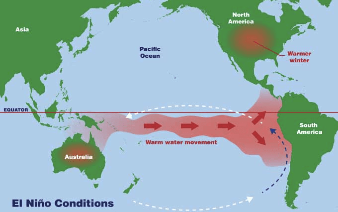
- The change in pressure condition over Pacific Ocean is known as Southern Oscillation.
- The combined phenomenon of southern oscillation and El Nino is called ENSO.
Types of Winds
Trade Winds – These winds blow from sub-tropical high- pressure belt to equatorial low-pressure belt between 300N and 300S. they blow as N-E trades in northern hemisphere and S-E trades in southern hemisphere.
Westerlies – These winds blow sub-tropical high pressure to sub-tropical low pressure between 300 and 600 on either side of equator. These are known as westerlies because they blow out of west. They are also known as Roaring Forties or Brave West Winds or Furious Fifties.
Polar winds – These blow from polar high-pressure belt to sub-polar low pressure belt between 600 and poles on either side of equator. These are extremely cold and dry.
Seasonal Winds – Winds that change their directions with the onset of a new season. For ex- Monsoon winds which changes direction between summer and winter.
Local Winds – These winds blow only during a particular period of a day. For ex – land and sea breeze.
- Sea Breeze – During the day, the land heats up faster and becomes warmer than the sea. It results in rising of air over land creating a low-pressure area. During this period, temperature of sea is low and pressure over it higher than the land. Hence, the wind starts blowing from sea to land as sea breeze.
- Land Breeze – During night, the condition reverses. The land loses heat faster and is cooler than sea. High pressure is created over land which results in movement of air from land to sea as Land breeze.
Mountain and Valley Winds
- In mountain regions, the slope gets heated up during the day and air moves upwards and to fill the resulting gap, air from the valley blows up the valley. This is known as Valley breeze.
- During the night, the slopes get cooled and the dense air descends into the valley as the mountain wind.
Fronts
The boundary zone between the meeting point of two different air masses is called Front. The process of formation of front is called frontogenesis. There are four types of fronts –
- Stationary front
- Cold front – When the cold air moves towards the warm air mass, its contact zone is called cold front.
- Warm front – When warm air moves towards the cold air mass, it creates warm front.
- Occluded front – If an air mass is fully lifted above the land surface, it is known as occluded front.
Tropical Cyclones
These are violent storms originate over oceans in tropical areas and move towards the coastal areas bringing about huge destruction.
Conditions for Formation of Cyclones
- Large sea surface with temperature higher than 270C
- Presence of Coriolis force
- Small variations in vertical wind speed
- Weak low-pressure area
- Upper divergence above sea level system
Formation of Cyclone
A cyclone is formed when warm, moist air near the ocean surface rises upwards. The rising of air from the ocean surface creates a low pressure over the oceans. It causes air from high pressure areas to move towards it and causing it to climb above.
- Eye of a cyclone – It is the centre of origination of cyclone with low pressure and calm air.
- Landfall of the cyclone – The place where a tropical cyclone crosses the coast is called the landfall of cyclones.
Thunderstorms
It is a local storm occurring over a small area. It is caused by intense convection on moist hot days. A thunderstorm is a well grown cumulonimbus cloud producing thunder and lightning.
- When the clouds extend to heights where sub-zero temperature prevails, hails are formed and they come down as hailstorms.
- If there is insufficient moisture, a thunderstorm can generate dust storms
Tornadoes – From severe thunderstorms, sometimes spiralling wind descends with greater force, with very low pressure at the centre. Such a phenomenon is called Tornado. The tornadoes over the sea is called water spouts.
Water in the Atmosphere
Humidity
- The amount of water vapour present in the atmosphere is known as humidity.
- The ability to hold water depends entirely on its temperature.
- The percentage of moisture present in the atmosphere as compared to its full capacity is called relative humidity.
- Humidity is greater over the oceans than over the land.
- The air containing moisture to its full capacity at a given temperature is said to be saturated. The temperature at which saturation occurs is called Dew Point.
- Humidity is measured by Hygrometer.
Evaporation and Condensation
- Evaporation is process in which water is converted to vapour. Heat is the main cause of evaporation.
- The temperature at which evaporation occurs is known as latent heat of vapourisation.
- Greater the movement of air, greater is the evaporation.
- Condensation is the process of converting water vapour to water. It is caused by loss of heat.
- The favourable conditions for condensation are dew point and decrease in air temperature.
- If the vapours directly condense to solid without becoming liquid, the process is called sublimation.
Dew
- When the moisture is deposited in the form of water droplets on cooler surfaces of solid objects like leaves of plants, stones etc., it is known as dew.
- The ideal conditions for dew formation are – clear sky, calm air, high relative humidity and cold and long nights.
- The dew point must be greater than freezing point for formation of dew.
Frost
- When condensation takes place below freezing point, frost is formed.
- The excess moisture is deposited in the form of minute ice crystals.
- Ideal conditions – air temperature must be below the freezing point, clear sky, calm air, high relative humidity and cold and long nights.
Fog and Mist
- Fog and mist are formed when temperature of an air mass containing a large quantity ofwater vapour falls suddenly and condensation takes place on fine dust particles.
- Fog and mist are the clouds with their bases at or very near to the ground.
- The only difference between mist and fog is that mist contains more moisture than fog.
- Mists are frequent over mountains while fog occurs where warm currents of air come in contact with cold air.
Clouds
It is a mass of minute water droplets or tiny crystals of ice formed by the condensation of water vapour in free air at considerable elevations. They are of four types depending on height, density, transparency or opaqueness –
- Cirrus – These are formed at high altitudes (8000-12000m). They are thin and detached clouds having a feathery appearance. They are always white in colour.
- Cumulus – They look like cotton wool and are formed at a height of 4000 to 7000m. They exist in patches and have a flat base.
- Stratus – These are layered clouds covering a large portion of sky. These clouds are formed due to loss of heat or mixing of air masses with different temperatures.
- Nimbus – These are black or dark grey in colour. They formed very near to the surface of earth. These are shapeless masses of thick vapour.
Precipitation
- After the condensation of water vapour, the release of moisture is called precipitation. This may take place in liquid or solid form.
- Precipitation in the form of water is called rainfall. When the temperature is below 00C, precipitation takes place in the form of snow, which is called snowfall.
- Sleet – It is frozen raindrop and refrozen melted snow water. When a layer of air with the temperature above freezing point overlies a subfreezing layer above the ground, precipitation takes place in the form of sleet.
- Hailstones – Sometimes, drops of rain water being released by the clouds become solidified into small solid pieces of ice, it is called hailstones.
TYPES OF RAINFALL
Convectional Rain
- This rainfall occurs during high temperature when the warm air rises up in theatmosphere. On expansion, air cools down and clouds are formed.
- These clouds bring heavy rainfall which lasts for a short duration.
- Such rain is common in the summer or in the hotter part of the day.
- It is very common in equatorial regions and interior parts of the continents.
Orographic Rain
- It occurs when the saturated air mass comes across a mountain and it is forced to ascend.
- As it rises, it expands, the temperature falls and moisture is condensed.
- This type of rain majorly occurs on the windward side and it is also known as relief rain.
Cyclonic Rain
- This type of rainfall is caused due to cyclones.
- A cyclone has a warm front and a cold front with a substantial difference in the temperatures. This difference causes the air above the warm front to rise up and expand.
- The expansion causes the temperature to drop and condensation occurs, which results in the formation of clouds.
- These clouds bring heavy rainfall which may even go on for several days.
Solar Radiation & Temperature
The solar energy received by the earth’s surface is called insolation. Due to its shape, the earth receives solar radiation obliquely.
- Due to variation in distance between earth and sun, the solar output received at the top of the earth’s surface varies in a year.
- During its revolution around the sun, the earth is farthest from the sun on 4th July. This position is called Aphelion.
- On 3rd January, the earth is nearest to the sun and this position is called Perihelion.
- Hence the annual insolation received by the earth is slightly more on 3rd January than on 4th July.
- The insolation received at the surface varies from about 320 watt/m2 in the tropics to 70 watt/m2 in the poles.
- Maximum insolation is received over the subtropical deserts where cloudiness is the least.
- At the same latitude, insolation is more over the continent than over the oceans.
Factors responsible for variation in insolation
- Rotation of earth on its axis
- Angle of inclination of sun’s rays
- Length of the day
- Transparency of the atmosphere
- Configuration of land
Terrestrial Radiation
- The insolation received by the earth is in short wave forms and heats up its surface. The earth after being heated itself becomes a radiating body and it radiates energy to the atmosphere in long wave form. This energy heats up the atmosphere from below and this process is known as terrestrial radiation.
- These long wave radiations are absorbed by green house gases
Temperature
The interaction of insolation with the atmosphere and the earth’s surface creates heat which is measured in terms of temperature. It is the degree of hotness or coldness.
Factors Controlling Temperature Distribution
- Latitude of the place – Since insolation varies according to the latitude and hencetemperature varies
- Altitude – Places near the sea level have higher temperature as compared to the places at higher elevations
- Distance from the sea – Places near the sea are warm as compared to the places far away from the sea
- Air mass and ocean currents – places which come under the influence of warm air masses experience higher temperature.
Temperature Inversion
- Generally, temperature decreases with increase in height. This known as normal lapse rate. But sometimes the situation is reversed and the normal lapse rate is inverted. This situation is known as temperature inversion.
- A long winter night with clear skies and still air is the ideal situation for inversion.
- Inversion takes place in hilly areas due to air drainage.