Skip to content
Philoid
Browse Saved
Back to chapter
Geography
All India 2016
Home · Class 12 · Geography · Ref. Book · All India 2016
Prev
Next
Q21 of 42 Page 1

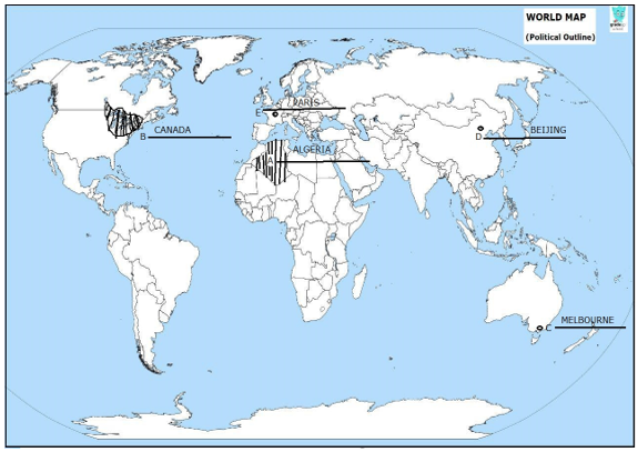
Identify the five Geographical features shown on the political outline map of the world as A, B, C, D and E and write their correct names on the lines marked near them with the help of the following information

A. The country with the largest area in Africa


B. An area of dairy farming


C. A major seaport


D. An international airport


E. A megacity


More from this chapter

All 42 →
19

‘Fragmentation of landholding' and ‘degradation of cultivable land' are a serious problem of Indian agriculture. Suggest and explain measures to overcome this problem.

20

Which is the apex body in India to improve the quality of national highways? Examine the significance of national highways.

21

Note: The following question is for the Visually Impaired Candidates Only in lieu of Q. No. 21:


A. The country with the largest area in Africa


B. An area of dairy farming


C. Name any major seaport of Australia


D. Name any international airport in South America

22

Locate and label the following features with appropriate symbols on the given outline map of India:

i. The state with the lowest density of population


ii. The state with the highest density of population


iii. A major copper mining area in Southern Rajasthan


iv. The integrated iron and steel plant located in Chhattisgarh


v. The international airport located in Assam

Questions · 42
All India 2016
1 2 3 4 5 6 7 8 9 9 10 11 12 12 13 14 15 16 17 18 19 20 21 21 22 22 1 3 4 5 7 11 17 20 1 3 4 5 7 11 17 20
Back to chapter
ADVERTISEMENT
About Contact Privacy Terms
Philoid · 2026
  • Home
  • Search
  • Browse
  • Quiz
  • Saved