Skip to content
Philoid
Browse Saved
Back to chapter
Geography
Delhi 2016
Home · Class 12 · Geography · Ref. Book · Delhi 2016
Prev
Q22 of 22 Page 1

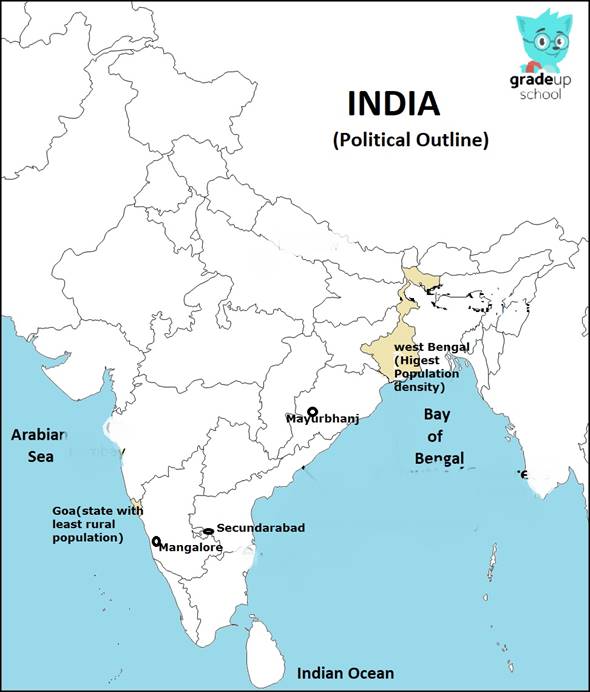
Locate and label the following on the given political outline map of India with

appropriate symbols.


(i) The state having the highest density of population (2011).


(ii) The state with the smallest rural population.


(iii) Mayurbhanj – an iron ore mining area.


(iv) An oil refinery in Karnataka state.


(v) The headquarter of South Central Railway Zone.


More from this chapter

All 22 →
18

Explain why the causes of male and female migration are different in India. Find out the

environmental consequences of migration.

19

“‘Erratic monsoon’ and ‘Indebtedness’ are the major problems of Indian agriculture.”

Suggest and explain the measures to overcome these problems.

20

Why is the distribution of roads not uniform in India? Explain with example

21

Five Geographical features are shown on the given political outline map of the World as A,

B, C, D, and E. Identify these features with the help of the information given below and


write their correct names on the lines marked near them :


(A) The country with the lowest density of population in Asia.


(B) An area of nomadic herding.


(C) A major seaport.


(D) An International airport


(E) A megacity

Questions · 22
Delhi 2016
1 2 3 4 5 6 7 8 9 10 11 12 13 14 15 16 17 18 19 20 21 22
Back to chapter
ADVERTISEMENT
About Contact Privacy Terms
Philoid · 2026
  • Home
  • Search
  • Browse
  • Quiz
  • Saved