Skip to content
Philoid
Browse Saved
Back to chapter
Geography
All India 2018 (Compartment)
Home · Class 12 · Geography · Ref. Book · All India 2018 (Compartment)
Prev
Next
Q21 of 26 Page 1

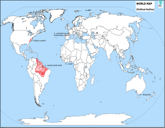
In the given political outline map of the world, five geographical features are marked as A, B, C, D and E. Identify them and write their correct names on the lines marked, near them, with the help of the following information:

(A) A major sea-port.


(B) An International airport.


(C) An Industrial region.


(D) An area of subsistence gathering.


(E) A mega ci


More from this chapter

All 26 →
19

Explain any five favourable factors responsible for the development of ‘Mumbai-Pune’ industrial region.

20

“The Indian seaports are the gateways of the international trade.” Justify the statement.

21

Note: The following questions are for the Visually Impaired Candidates only, in lieu of Q. No. 21:


(i) Name any one major sea-port of Australia.


(ii) Name the international airport in Italy.


(iii) Which is the major industrial region of Germany?


(iv) Mention the area of subsistence gathering in Brazil.


(v) Name the megacity of Nigeria.

22

Locate and label the following Geographical features on the Political Outline map of India with appropriate symbols:

(i) The leading Coffee producer State.


(ii) An important Coal mining area in West Bengal.


(iii) An important Centre of Cotton Textile Mills in Madhya Pradesh.


(iv) An important seaport in Odisha.


(v) The State with the lowest density of population.

Questions · 26
All India 2018 (Compartment)
1 2 3 4 5 6 7 8 9 10 11 12 13 13 14 15 15 16 17 18 19 20 21 21 22 22
Back to chapter
ADVERTISEMENT
About Contact Privacy Terms
Philoid · 2026
  • Home
  • Search
  • Browse
  • Quiz
  • Saved