Skip to content
Philoid
Browse Saved
Back to chapter
Geography
Sample Paper - 2018-19
Home · Class 12 · Geography · Ref. Book · Sample Paper - 2018-19
Prev
Next
Q21 of 26 Page 1

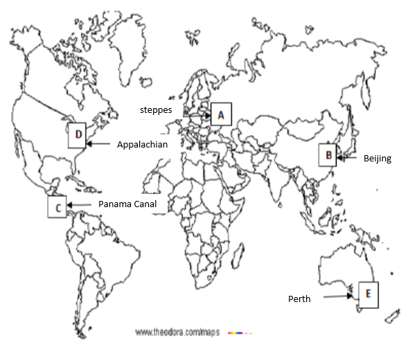
Five Geographical features are shown on the given Political outline map of the world as A, B, C, D and E. Identify these features with the help of the key given below and write their correct names on the blanks marked on the map near them.

A-Area of Mixed Farming


B-A major airport of Asia


C-A waterway


D-Industrial region


E-A major seaport of Australia


More from this chapter

All 26 →
19

Analyse the factors that favoured the concentration of iron and steel industries in the Chhota Nagpur region in India.

20

Identify the challenges of the adolescent population before society. Enlist a few measures to overcome these problems.

21

For Visually Impaired Candidates (in place of Q. No. 21)

A-Name any area of mixed farming in Europe.


B-Name any international airport of China.


C-Name the important waterway of Central America.


D-Mention an important industrial region of Eastern USA.


E-Name the important seaport of Australia.

22

Locate and label any five of the following on the given political outline map of India.

a. The state having the lowest work participation rate


b. Major seaport located in Odisha.


c. The international airport in Punjab.


d. Iron ore mine in Karnataka.


e. The cotton textile industry in Gujarat.


f. The state with highest literacy rate.


g. Headquarter of Northwestern railway zone.


h. The biggest seaport of India.

Questions · 26
Sample Paper - 2018-19
1 2 3 4 5 6 7 8 9 10 10 11 12 13 13 14 15 16 17 18 19 20 21 21 22 22
Back to chapter
ADVERTISEMENT
About Contact Privacy Terms
Philoid · 2026
  • Home
  • Search
  • Browse
  • Quiz
  • Saved